
Technology has evolved.
The goal has always been the same.
How LiDARUSA used mobile LiDAR to document Baltimore damage in 2015.
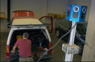
In 2015, LiDARUSA donated equipment use and services to help Baltimore police document damage following civil unrest. Working alongside a police crime lab technician, a LiDAR engineer from LiDARUSA deployed Snoopy, the company’s ScanLook 2.0 mobile mapping system. High-accuracy LiDAR and 360-degree imagery captured the surveyed surroundings in full 3D—a digital twin of conditions at the time of collection.
Project year: 2015 · Case study published:
More than photographs.
A measured record.
Mobile scanning brought geometry and visual context together, preserving a three-dimensional view of the streets and structures captured by the system.
- Location
- Baltimore, Maryland
- Project year
- 2015
- System
- Snoopy · ScanLook 2.0
- Platform
- Police SUV
- Capture
- Mobile LiDAR + 360-degree imagery
- LiDARUSA contribution
- Donated equipment use and services
A city in recovery. A record in 3D.
After the unrest, Baltimore needed a record of damaged buildings and streets. LiDARUSA supplied a mobile mapping system and field expertise to support that effort. The assignment brought engineering-grade capture into a public-safety setting, where documenting the scene was the immediate priority.
Contemporary reporting described the goal as documenting the extent of damage and supporting assessment, investigation, and future planning. Those were the intended uses of the record—not a claim that every possible downstream use was completed.
How did LiDARUSA document damage in Baltimore?
A LiDAR engineer from LiDARUSA mounted Snoopy on a police SUV and worked alongside a Baltimore police crime lab technician. As the vehicle moved through the affected streets, the system recorded the surrounding environment using laser scanning and panoramic imagery.
The ScanLook 2.0 configuration combined LiDAR scanning with the GoLook camera system’s 360-degree views. Bringing the equipment onto a vehicle made street-level collection part of a mobile workflow rather than a sequence of isolated photographs.
How do LiDAR and 360-degree imagery create a colorized point cloud?
LiDAR measures the position of surfaces in three dimensions. The imagery adds visual context: the appearance of a façade, the condition of an opening, or details around a structure. Aligning the imagery with the measured points creates a colorized point cloud that combines geometry and appearance in one digital record.
For the Baltimore project, Snoopy captured the surveyed surroundings in full 3D. That record preserved the conditions visible to the sensors at the time of collection; it was not a claim of complete coverage of every building or interior in the city.
How can engineers use a point cloud for design?
Engineers can visually inspect captured structures, take measurements, and use the point cloud as a foundation for existing-condition models and design work. Its usefulness depends on coverage, positioning, accuracy checks, and the requirements of the intended deliverable.
These are broader capabilities of the workflow. They should not be read as confirmation that the Baltimore dataset was used for a particular reconstruction design.
What LiDAR system should I use for public safety, forensic mapping, and natural disasters?
Start with the job: the size and accessibility of the scene, required accuracy, imagery needs, and the final deliverable. A lightweight, accurate, multi-platform LiDAR system with integrated imagery can help a team move between aerial and ground-based collection.
For aerial missions
For public-safety teams, drone operation is often a secondary duty. Straightforward flight and acquisition workflows matter alongside the capabilities of the sensor. Where NDAA requirements apply, the aircraft, LiDAR, camera, and complete configuration should be reviewed together.
LiDARUSA recommends the Patriot X4 with a Liberty NDAA configuration and Sony 61 MP camera as a cost-conscious starting point for these missions. Explore Liberty NDAA and ask our team about availability and the configuration appropriate to your program.
For high-accuracy mobile mapping
For demanding ground-based forensic mapping, discuss the Highway Mapper and Surveyor VUX with a 360-degree camera. Match the scanner, positioning system, imagery, and collection plan to the accuracy and coverage the project requires.
These are present-day recommendations, not the equipment configuration used in Baltimore in 2015.
Technology has evolved. The goal has always been the same.
More than a decade later, the technology has advanced. The goal remains the same: capture real conditions and turn them into information people can use.
The Baltimore assignment reflects that purpose—bringing a mapping system, an engineer, and field support together to help document a place when an accurate record mattered.
Build your mapping workflow around the job.
Tell us what you need to document, how you plan to collect it, and the deliverable your team needs.